Greenridge Sabre Uranium Property Location and Claim Map
OWNERSHIP : Greenridge 100%
SIZE : 28 claims covering 23,178 ha acquired by staking in 2021.
LOCATION: Northern margin of the Athabasca Basin near Richards Lake, SK, ~ 60 km west of the Hamlet of Stony Rapids, which has year-round all-weather road access and a commercial airport.
Regional Significance
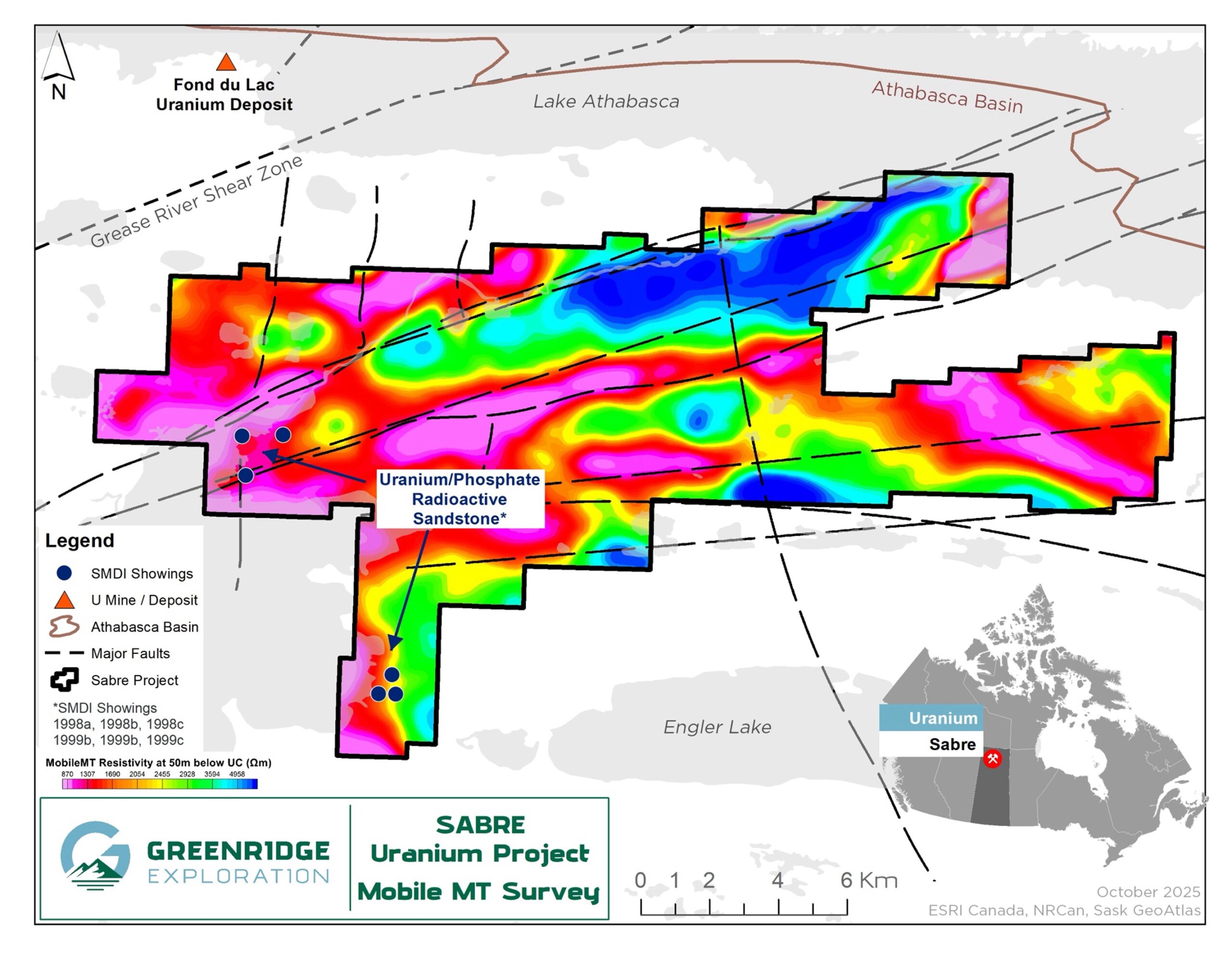
The property is situated within the Snowbird Tectonic Zone, a major geological structure that transects the Athabasca Basin and includes several parallel northeast-trending fault zones including the Black Lake Fault. Prospective for unconformity-style deposits.
The historic Nisto Mine, which produced ~96 tonnes grading 1.38% U3O8 in the 1950s is located on the northwest side of the Black Lake fault to the east of the property. The Fond du Lac uranium deposit, a small shallow uranium discovery found in 1970 is located 15km northwest of the Sabre property.
Underexplored district with relatively shallow depths to the Athabasca sandstone unconformity (estimated to range from 210 to 420 m), with potential for unconformity-style or deeper, basement-hosted uranium mineralization.
Greenridge Sabre Uranium Property Location and Claim Map
Sabre Uranium Geology Map
sabre uranium
Highlights of the 2022 Sabre Prospecting Program
Sabre Uranium Geology Map
On October 25, 2022 Greenridge announced the completion of a prospecting program at Sabre. Two radioactive zones were located on surface in the Athabasca sandstone by Greenridge’s prospecting team adjacent to an interpreted structural zone of quartz vein brecciation.
A significant trend of structural disruption in the Athabasca sandstone known as the Jigsaw Zone was discovered. The structure is exposed at surface as quartz veining and local quartz-breccia in abundant angular boulders (i.e., not far-traveled by glacial movement), sub-crop and outcrop of sandstone and can be traced over a trend approximately 150 metres long by 15 metres wide. The Jigsaw Zone is open along strike to northeast and southwest and disappears under cover in both directions.
A trend of elevated radioactivity in boulders in possible outcrop or subcrop was located 15 metres to the south of Jigsaw Zone and is presumed to be a historical uranium-phosphate showing first reported in 1979. Two small pits (“West” and “East”) were hand dug by Greenridge to better expose the radioactive sources.Scintillometer readings of up to 550 counts per second (“cps”) and 250 cps were obtained from inside the bottom of the West and East pits, respectively (10 to 20 times background radiation levels).
sabre uranium
Highlights of the 2022 Sabre Prospecting Program
The elevated radioactivity in the West and East pits is associated with dark purple to red sandstone with bleached patches and local spots of a very pale greenish alteration.Samples at the West Pit may be associated with frost-heaved subcrop or a very large boulder. Greenridge considers the radioactive sandstone found at the Jigsaw Zone highly significant, considering the depth to basement is estimated to be at least 300 metres, which implies the occurrence of a significant hydrothermal event that carried silica-rich and uranium-bearing fluids to surface.
Four samples of the quartz vein and quartz-breccia sandstone from the Jigsaw Zone and four radioactive samples from the West and East pits adjacent to the Jigsaw Zone were submitted to the Saskatchewan Research Geoanalytical Labs in Saskatoon, Saskatchewan for a full suite of geochemical analyses. In addition, sub-samples were submitted for short-wave infrared spectroscopy (SWIR) analyses to determine the clay signature of the samples.Results showed anomalous values of uranium and phosphate in the samples.
Fig1. Greenridge Sampling at the Weat Pit, Fig.2. Radioactive Sandstone Sample
Sabre MT Survey
Sabre 2023 TDEM survey results: a new drill target
sabre uranium
2023 Geophysical Survey
Outline of the 2005 MegaTem survey over the current Sabre property – warm colours are interpreted conductivity
In early 2023, Greenridge carried out a ground Time Domain Electromagnetic (“TDEM”) survey to follow-up on the results of a historical MegaTem airborne survey flown in 2005.
In 2006, UEX Corporation (“UEX”) drilled hole ML-02 without the benefit of a confirmatory ground EM survey and did not intersect the interpreted airborne conductor. Greenridge’s 2023 TDEM survey results over the area of hole ML-02 confirmed a basement conductor near the drillhole. Computer modeling of the 2023 TDEM conductor in relation to the collar location of hole ML-02 showed that UEX’s drillhole missed the targeted conductor by approximately 275 metres, thus creating a new and well-defined drill target at Sabre.
Additional work at Sabre in 2024 may include airborne magnetic/radiometric surveys, airborne electromagnetic surveys, surface prospecting, mapping and Spatiotemporal Geochemical Hydrocarbon (“SGH”) soil surveys across the highest-priority areas to optimize potential drill targets.
Sabre 2023 TDEM survey results: a new drill target
Exploration Programs Pre-2008
Historical prospecting discovered uranium-bearing sandstone boulders and outcrop with up to 375 parts per million (“ppm”) uranium.
Only 5 historical drill holes on the property, which identified intense dravite alteration and significant hydrothermal activity.
Drill testing for uranium within the current boundaries of the Project is limited to five (5) historical drill holes. Hole ML-02, drilled by UEX Corporation in 2006, intersected highly anomalous dravite veining (a boron-rich clay mineral) in the sandstone at a depth of 290.5 metres, which is a clay alteration mineral commonly associated with uranium deposition in the Athabasca Basin.
National Instrument 43-101 Disclosure
The technical information on this web page has been reviewed and approved by Sierd Eriks, P.Geo. (Retired), who is a Qualified Persons in accordance with the Canadian regulatory requirements set out in NI 43-101. Readers are cautioned that some of the technical information described on this web page is historical in nature; however, the historical information is deemed credible and was produced by professional geologists/geoscientists in the years discussed.