~20 km northeast of Fission Uranium’s Triple R uranium deposit.
~8 km northeast of Cameco/Orano/Purepoint’s Spitfire, Hornet and Dragon discoveries.
Outlook and Planned Exploration
No work undertaken since 2019.
Highly prospective for continued exploration, which to date suggests the presence of a large mineralized system on the property.
Exploration Summary 2017-2019
In 2019, six drill holes totaling 4,797m, identified favourable structure and alteration in the most drill holes, in addition to significant concentrations of uranium pathfinder elements.
In 2018, two drill programs totalling 6,960m in nine drill holes were completed. Strong hydrothermal alteration in sandstone and basement lithologies associated with graphitic basement structures encountered.
Ground resistivity and electromagnetic surveys identified the 2018-19 drill program targets.
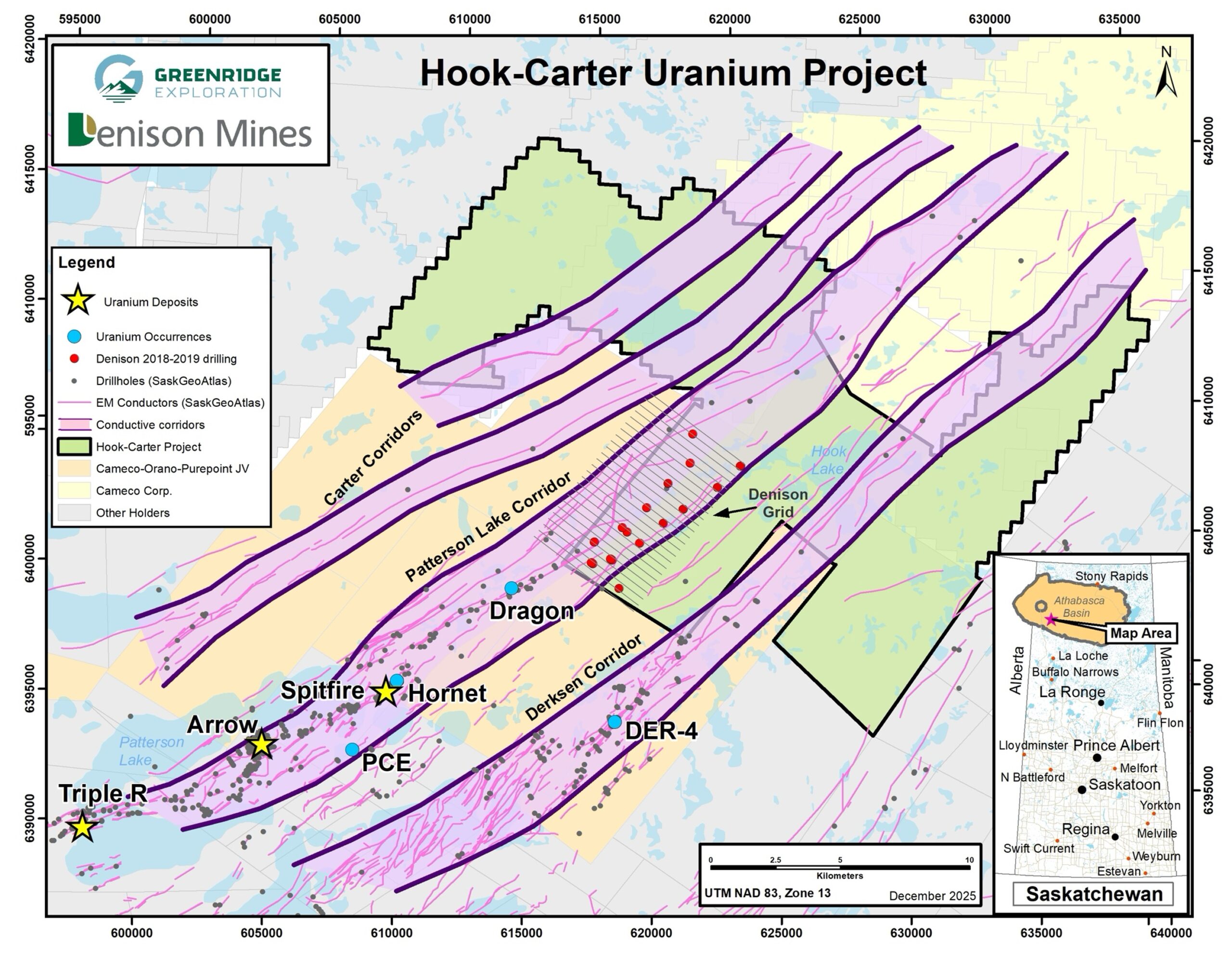
Hook-Carter Claim Map
Hook-Carter uranium
OVERVIEW
Ownership
Greenridge 20% – Denison Mines 80% after sale to Denison in 2016 for 7.5 million common shares of Denison and a minimum spend requirement of $3 MM in exploration. Denison has funded $7.05 million in exploration to date. The property is subject to certain royalties held by underlying vendors.
Greenridge can earn an additional 5.0% funding $3.0 million of exploration at Hook-Carter within a 30-month period from May 21, 2024, which would change the joint venture participating interests to Greenridge 25% – Denison 75%.
SIZE : 11 claims covering 25,115 ha.
LOCATION: SW margin of the Athabasca Basin within the Patterson Lake corridor; ~27km east of provincial highway 955.
Hook-Carter Geology Map
Hook-Carter Geology Map
Hook-Carter uranium
PREVIOUS WORK
Hook-Carter Previous Work
Denison’s 2023 airborne ZTEM survey confirmed the presence of multiple NE-SW trending conductors trending through Hook-Carter and connecting to the EM conductors identified on Cameo Corporation’s William River property to the north.
Denison has drilled only 15 exploratory drillholes during 2018-2019 in a small section of the property – the hallmarks of a prospective setting for uranium mineralization such as graphitic horizons and alteration minerals were intersected in that drilling.
Strong hydrothermal alteration in sandstone and basement lithologies associated with graphitic basement structures were encountered, in addition to significant concentrations of uranium pathfinder elements.
Highly prospective for continued exploration, which to date suggests the potential presence of a mineralized system on the property. A follow-up drilling program of 6 to 8 diamond drill holes is planned for the winter of 2026.
Hook-Carter Previous Work
Hook-Carter uranium
PREVIOUS WORK
Located in the SW margin of the Athabasca Basin within the Patterson Lake Corridor, located ~27km east of Provincial Highway 955.
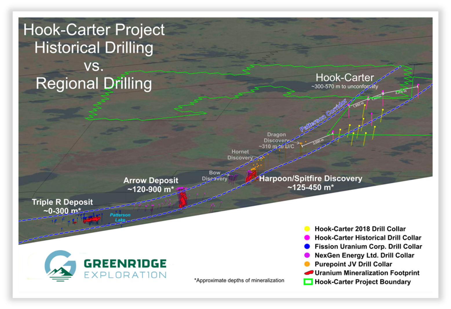
The Patterson Lake Corridor (PLC), an interpreted geological feature which hosts the Triple R (Paladin Energy Limited) and Arrow (NexGen Energy Ltd.) uranium deposits, and trends northward onto Hook-Carter. A joint venture of Purepoint Uranium Group Ltd. (21%)-Cameco Corporation (39.5%)-Orano Canada (39.5%) adjoins Hook-Carter where the Spitfire, Dragon and Lightning uranium occurrences have been discovered by drilling.
A new uranium discovery by NexGen Energy Ltd. called “Patterson Corridor East” located 3.5km due east of Arrow implies that the PLC may be wider than was originally thought.
Parallel to and east of the PLC, the Derkson Corridor (“DC”) also trends onto Hook-Carter. The DC was found to be uranium-mineralized from historical drilling to the south of Hook-Carter but has not yet been drill tested on Greenridge’s property.
Hook-Carter Previous Drilling
Hook-Carter Previous Drilling
National Instrument 43-101 Disclosure
The technical information on this web page has been reviewed and approved by Sierd Eriks, P.Geo. (Retired), who is a Qualified Persons in accordance with the Canadian regulatory requirements set out in NI 43-101. Readers are cautioned that some of the technical information described on this web page is historical in nature; however, the historical information is deemed credible and was produced by professional geologists/geoscientists in the years discussed.