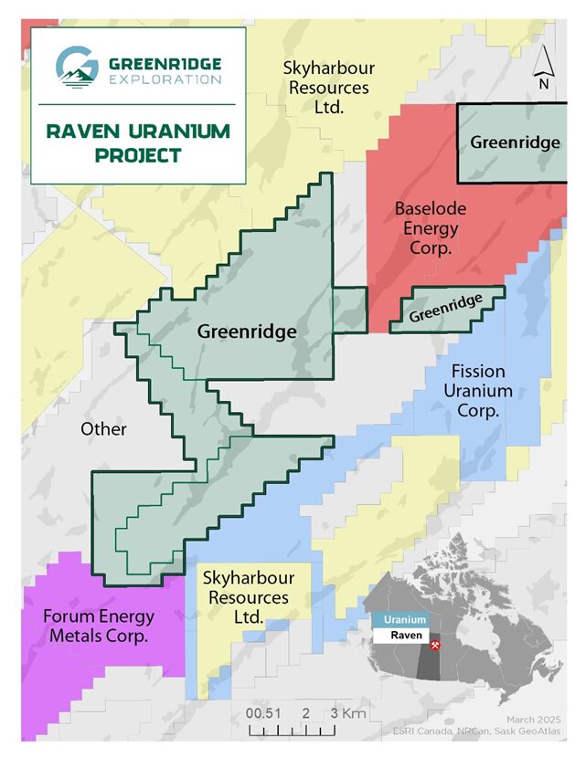
Greenridge Raven Uranium Property Location and Claim Map
OWNERSHIP : Greenridge 100%.
SIZE : 6,269 ha.
LOCATION: Athabasca Basin ~65km southeast of Cameco’s McArthur River Uranium Mine, one of the world’s largest high-grade uranium deposits.
Regional Significance
Located near the eastern margin of the Athabasca Basin about 65 kilometres southeast of Cameco Coporation’s McArthur River Uranium Mine. Raven is located outside of the eastern margin of the Athabasca Basin within the central parts of the Wollaston Domain basement rocks, which host prolific uranium mines such as Key Lake, McArthur River, Cigar Lake, and Rabbit Lake, amongst others.
Basement-hosted uranium deposits are actively explored for outside the current Athabasca Basin margin, with multiple recent major discoveries such as the Triple R deposit (“Triple R”) found in 2012 in the southwestern Athabasca Basin at Patterson Lake.
In the past three years, discoveries of high-grade uranium mineralization have been reported in the southeastern region outside the Athabasca Basin margin by exploration companies such as Atha Energy Corp. and Baseload Energy Corp.
Greenridge Raven Uranium Property Location and Claim Map
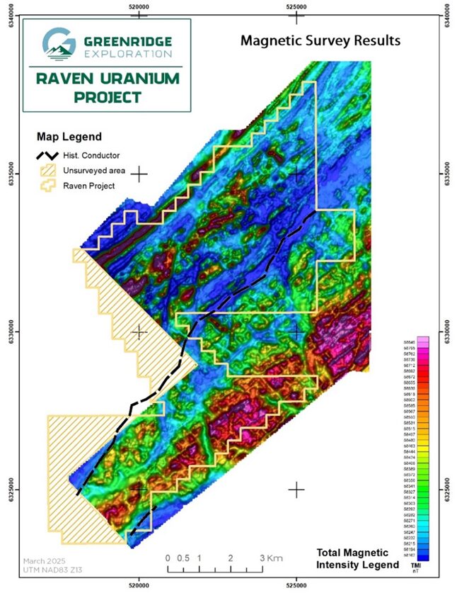
Raven Uranium Magnetic Survey Map
raven uranium
Geology
Raven Uranium Magnetic Survey Map
Raven hosts more than nine (9) kilometres of a historical electromagnetic conductor coincident with a prominent northeast-southwest trending magnetic low. Structural trends such as these which are cross-cut by interpreted brittle faults are considered to be a prospective setting for uranium mineralization in the Athabasca Basin region. There are no known historical drill holes on Raven.
raven uranium
2025 Exploration Plans
Greenridge owns data from a 2021 high-resolution airborne magnetic and radiometric survey flown over the Property area, which is the same system used to detect buried uranium-bearing boulders at Patterson Lake, Saskatchewan, thereby contributing to the discovery of Triple R in November 2012. The Company may carry out a helicopter-borne airborne electromagnetic survey in 2025 in conjunction with other surveys planned in the area, if logistics permit.
National Instrument 43-101 Disclosure
The technical information on this web page has been reviewed and approved by Sierd Eriks, P.Geo. (Retired), who is a Qualified Persons in accordance with the Canadian regulatory requirements set out in NI 43-101. Readers are cautioned that some of the technical information described on this web page is historical in nature; however, the historical information is deemed credible and was produced by professional geologists/geoscientists in the years discussed.