OWNERSHIP : Greenridge 40, JV with UEC (50.43%) and Orano Canada (8.57%).
SIZE : 12 claims covering 31,701 ha.
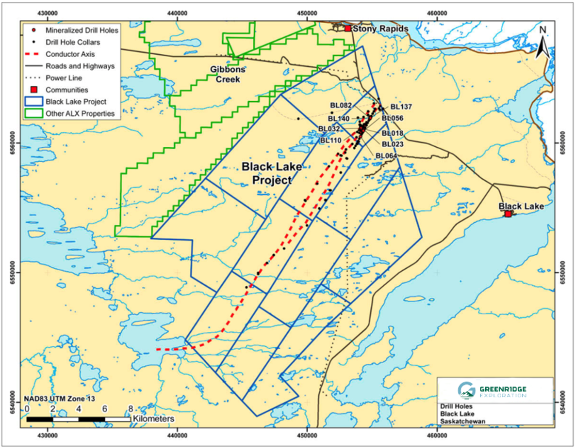
LOCATION: NE Athabasca Basin ~15 km south of the Hamlet of Stoney Rapids. Adjoins Greenridge’s Gibbons Creek Project. All-weather road and a nearby commercial airport provides year-round access.
Regional Significance
The historic Nisto Mine, which produced ~96 tonnes grading 1.38% U3O8 in the 1950s is located on the northwest side of the Black Lake fault near the property. The property overlays the Platt Creek Fault, which runs parallel to the regionally significant Black Creek Fault. The project is within driving distance of Orano Canada’s McClean Lake uranium mill.
Historical drilling by UEX Corp identified unconformity-style mineralization along a strike length of 1.7 km on the northern part of the property adjacent to the Eastern Fault, which runs parallel to the Black Lake Fault.
ProJECT OVERVIEW
Over $20.0 million has been spent on the property by UEX Corporation, Uracan, ALX and Uranium Energy Corp. Drilling in over 150 holes has focused mainly on the NE-SW conductor system.
Nine holes have intersected unconformity-type uranium mineralization since 2004 over a 1.7km strike length with values up to 0.69% U3O8 over 4.4m.
Discovery hole BL-18 showed that uranium mineralization had been distributed laterally along the unconformity, indicating a presumed nearby source.
Outlook and Planned Exploration
UEX’s geological theory discounted the possible effect of cross-cutting structures along the NE-SW conductor – as a result those NW-trending structures intersecting the conductive system have never been fully exploited, with no drilling since 2017.
An independent geological review of the property commissioned by Greenridge on all exploration completed to date concluded that target areas remain highly prospective for follow-up drilling.
Table 1. Black Lake Historical Mineralized Uranium Intersections
Black Lake Geology Map
Table 1. Black Lake Historical Mineralized Uranium Intersections
Black Lake Previous Drilling
black lake uranium
Exploration Summary 2017-2019
Black Lake Previous Drilling
In 2017 Greenridge completed an airborne ZTEM™ survey over the northern half of the property to complement a historical ZTEM™ survey flown in 2008 over the deeper, southern half of the property. The results provided important details of the multiple conductive structures at Black Lake to better define targets, which were followed up with a five hole drill program comprising 2,830m.
Drill Holes, BL-155 and BL-156 intersected narrow intervals of uranium mineralization. BL-155 returned 0.06% U3O8 over 0.15m from 316.69m to 316.84m and BL-156 intersected 0.03% U3O8 over 0.07m from 272.77m to 272.84m. Pitchblende veinlets and uranium pathfinder elements including nickel (up to 401 ppm), copper (up to 1,420 ppm), cobalt (up to 81 ppm) and boron (up to 195 ppm) were observed in the drill core.
In 2019, the Company completed a winter ground radon and helium survey at Black Lake. C.O. Geosciences Inc. of St-Lazare, Quebec developed for Greenridge a new technique of augering into frozen swamps to collect sediment samples for analysis. Approximately 160 radon and helium samples were collected and analyzed in the northernmost area of the property.
black lake uranium
PREVIOUS WORK
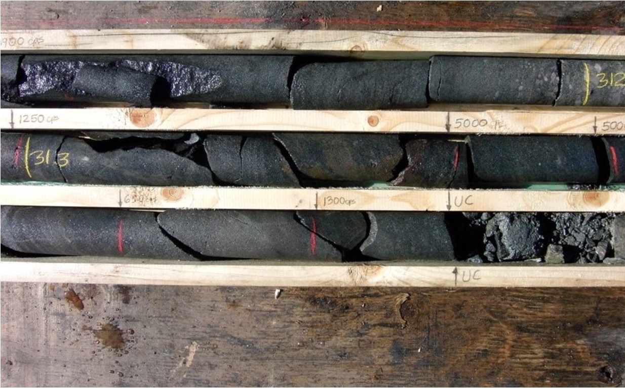
Hole BL-18: 4.4 metres of 0.694% U3O8, Sept. 2004
Drill Hole BL-18
Hole BL-18 marked a new uranium discovery at Black Lake in the Fall of 2004.
The drill hole encountered unconformity-type uranium mineralization in the sandstone immediately above the unconformity at a depth of 311.0 m.
Uranium mineralization occurs primarily as pervasive dark grey to black coffinite and pitchblende permeated into the matrix of the sandstone between quartz granules and pebbles.
The mineralized intersection averaged 0.694% U3O8 over 4.4 m between 310.5 and 314.9 m, including 0.848 % U3O8 over 3.3 m between 311.0 and 314.3 m, and 1.086 % U3O8 over 1.5 m between 312.8 and 314.3 m. Maximum grade in these intervals is 1.96% U3O8 over 0.5 m between 313.3 and 313.8 m.
Hole BL-18: 4.4 metres of 0.694% U3O8, Sept. 2004
National Instrument 43-101 Disclosure
The technical information on this web page has been reviewed and approved by Sierd Eriks, P.Geo. (Retired), who is a Qualified Persons in accordance with the Canadian regulatory requirements set out in NI 43-101. Readers are cautioned that some of the technical information described on this web page is historical in nature; however, the historical information is deemed credible and was produced by professional geologists/geoscientists in the years discussed.